Worldly known as a country of thousand hills, Rwanda has one of the world’s richest diversified cultural heritage, with both intangible and tangible components including sites that offer an incomparable view on the beauty of the country giving our visitors platform to learn about Rwandan history, mythology and culture. Going on a safari in Rwanda through the eastern province provides a fascinating insight into valuable heritage sites often located in beautiful countryside.
Today, more than ever before, the Institute of National Museums of Rwanda (INMR) is working hard to search and research on these sites as a way of identifying, protecting and promoting them for cultural tourism. Below are brief descriptions on some of the identified and valuable sites.
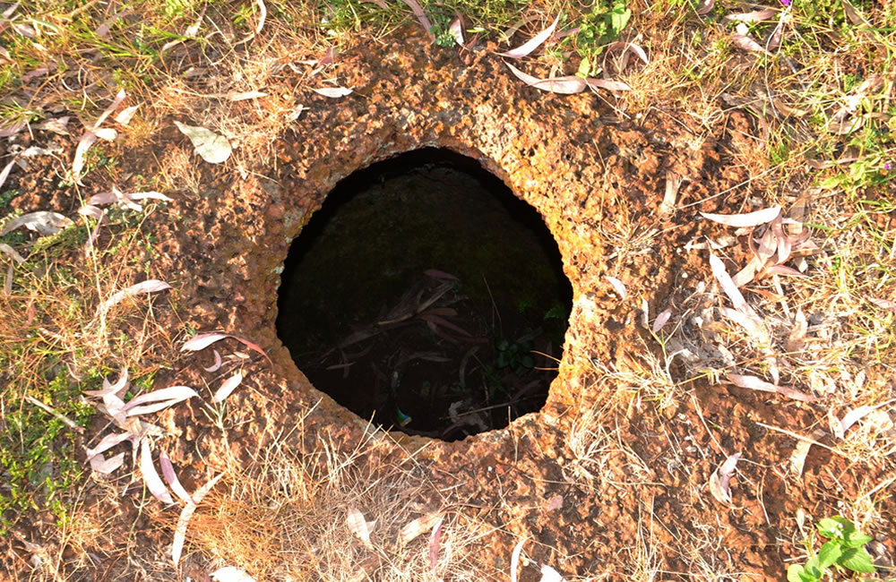
1. Utubindi twa Rubona
Utubindi twa Rubona is a cultural site located about 4 km from the main road Kayonza-Nyagatare; in Tubindi Village, Rubona Cell, Kiziguro Sector, Gatsibo District. The site itself lies within Rubona Primary School premises. It is a cluster of seven excavations shaped like clay pots without necks and rims; excavated in a hard granite rock. Despite their different sizes, the form of those pits is almost the same: it is a clay pot-shaped form, thus the site name Utubindi; the latter being a Kinyarwanda name which means small pots. Therefore, if one is to translate that name, it will be “the small pots of Rubona”.
In oral traditions, those pots have been excavated by King Ruganzu II Ndoli on his way from Karagwe (part of Eastern Tanzania). When that monarch and his men arrived there, they were thirsty and could not trace any natural water source around. Therefore, skillful Ruganzu used his magic spear and excavated those pits; and then drinking water rose in. Beside them but on the same rock, there are two features believed to be Ruganzu’s footprint and bow trace.
2. Urutare rwa Ngarama
Urutare rwa Ngarama is a cultural site located in Ngarama Sector, Gatsibo District; about 20 km from a place called Mu byapa bya Ngarama, on the main road Kigali-Nyagatare. Local people call it also Ibare rya Ngarama, ebare being the stone in Urukiga language. It is an impressive rock covering a surface of about 3 hectares on which there are features attributed to a historical figure, King Ruganzu Ndoli. Some of those features are footprints and an area which, if hit using a stone or metal, does resonate. For local people and oral traditions, those features have been affixed there by Ruganzu and remain a sign of his incredible knowledge and greatness.
Another version of oral traditions attributes those features to a mythical hero, Ngarama who killed Saruhara, hatched from Nkomokomo. The former being “an enormously powerful vulture which had long ravaged the region” before it was killed by Ngarama.
3. Ryamurari
Ryamurari is the name of a site located in Bufunda Village, Bufunda Cell, Mukama Sector, Nyagatare District. Being on the top of the hill called Mukama which stretches on about 50 hectares (Noten 1983:48), the site itself consists in three large earthwork structures and a stone cut reservoir. In oral traditions, Ryamurari was the capital of Ndorwa Kingdom before it was annexed to Rwanda.
The site was investigated in the 1970s, and dated layers indicate it was first occupied in the middle of the 17th century and re-occupied around 1900 AD (Noten et al. 1982:75). Much of the remains found there which include cattle bones and dung suggest that the inhabitants of that site were cattle-keepers. In addition, a number of grinding stones were recorded there and this suggests that, alongside animal husbandry, they also practiced agricultural activities (Noten 1983:48-49).
Ryamurari is one of prominent archaeological sites in Great Lakes Africa and remains a famous feature in both Rwandan archaeology and oral traditions. For archaeologists (e.g. Van Noten 1982, Tshihiluka 1983), its earthwork structures have apparently served as enclosures and, the size and direction of the labor force necessary to accomplish such work, together with the presence of abundant cattle remains, indicate the sign of cattle-keeping elite who told other people what to do.
What is striking about Ryamurari is also its names which show a correlation between archaeology, oral traditions and history. In fact, the hill on the top of which the site is located is called Mukama or Mu Bitabo bya Gahaya. In this region comprising Burundi, Rwanda, Ndorwa and Nkole, the name of Mukama means God, king or chief. Therefore, the fact of calling a hill Mukama may indicate that it was inhabited by the king or chief.
For the second name Mu Bitabo bya Gahaya, igitabo is a Kinyarwanda name which means a clay curved shape that was constructed before the entrance of a traditional hut. Therefore, Mu Bitabo bya Gahaya may imply a place that was inhabited by a great person called Gahaya. For the third name, Ryamurari commemorates the occupation of the site by a great person called Murari (Noten 1983:152).
In addition, oral traditions associate the earthwork structures which are on the top of that hill with a swampy depression with salty water located on its foot. It is believed that this depression was a trough for cattle of the king who has constructed those earthworks. Therefore, the link between archaeological finds from there and oral traditions as explained above suggests that Ryamurari is a seventeenth century capital of the Ndorwa Kingdom; and, obviously, the kings named Murari or Gahaya should have lived there (Noten 1982:75).
4. Mimuri
Mimuri is a site located near Mimuri local market; in Rebero Village, Rugari Cell, Mimuri Sector, Nyagatare District. The site itself is a cluster of five houses (3 in circular and 2 in trapezoid forms) built with metal sheets by King Mutara III Rudahigwa during early 1950s.
In fact, the region of Umutara was a savanna wood land and hunting was a major domain throughout the monarchical period. Therefore, as hunting was Rudahigwa’s hobby, he liked to go to hunt there. In addition, it was a tradition for Rwandan monarchs to go around their kingdom, for contemplating it, meeting chiefs and populace. That is the reason why Rudahigwa had to construct those houses as his hunting camp and a meeting place with the public and local chiefs. Actually, this site reflects early aspirations of King Rudahigwa’s development and modernity concerns as seen through the materials he used, as well as the architectural design which includes the chimney for warming up people during the traditional evening gatherings.
When the King was not there, the camp served as shelter to Rwandans who traveled to and from Uganda; and this shows the extent to which the monarch was close to his people.
The above described places are unique and have an outstanding value as cultural heritage sites. Visiting them is an opportunity of reaching some of the farthest corners of Rwanda, contemplating its beauty, gaining new insights in its mythology, culture and history. That is why INMR is working hard to identify, document and protect these valuable heritage site.
Leave a Reply